
Location. The cave is located in the Eastern European region, at the point where the borders of three states meet: Ukraine, Moldova, and Romania. One of the borders—the Moldovan-Ukrainian border—passes directly above the cave, dividing it into two parts: the northwestern Ukrainian part and the southeastern Moldovan part. The cave labyrinth extends from the entrance in the northwest (toward Ukraine) and northeast (toward Moldova) directions.
Cave entrance coordinates: X = 5473068, Y = 5349974.
Type and Host Rocks. The karst rocks hosting the cave are represented by gypsum (Nistru layers) and Middle Badenian chemogenic limestones (Ratin layers) (N1bd2). The gypsum in the cave area has a thickness of 23–26 m, while the limestone layer covering it measures 0.3–0.8 m.
Age. Several more or less conventional stages are distinguished in the speleogenesis of the cave, characterized by different peculiarities of karst development (Middle Badenian, Upper Badenian—Lower Sarmatian, Middle Sarmatian—Mesopleistocene, Neopleistocene—Holocene, and the current stage). The main phase of the speleogenesis of “Zolushka” (Cinderella) cave occurred at the end of the Neopleistocene.
Description. The cave is a network of passages combined into a giant labyrinth, the prerequisite for whose formation, according to most karst researchers in the region, is the tectonic fracturing of the gypsum. Due to the following patterns, we can confidently speak of the pronounced systemic nature of the labyrinth:
- the regular orientation of the system elements;
- the heterogeneity of the system elements along the perimeter of the cave and the pronounced homogeneity of the elements in its interior part. [1]
System elements include:
- Macro and meso elements: cave zones—spaces with morphological and morphometric independence; galleries, passages, fissures, and halls in whose formation the primary role is played by structural prerequisites, such as faults and fissures, as well as specific groundwater circulation conditions;
- Micro and nano elements: corrosive niches and recesses on the walls, chimneys on the vaults, irregularities associated with the alternation of layers of different textures, as well as the action of the crystalline structure of the rock, composed of grains of different sizes. [1, p.66]

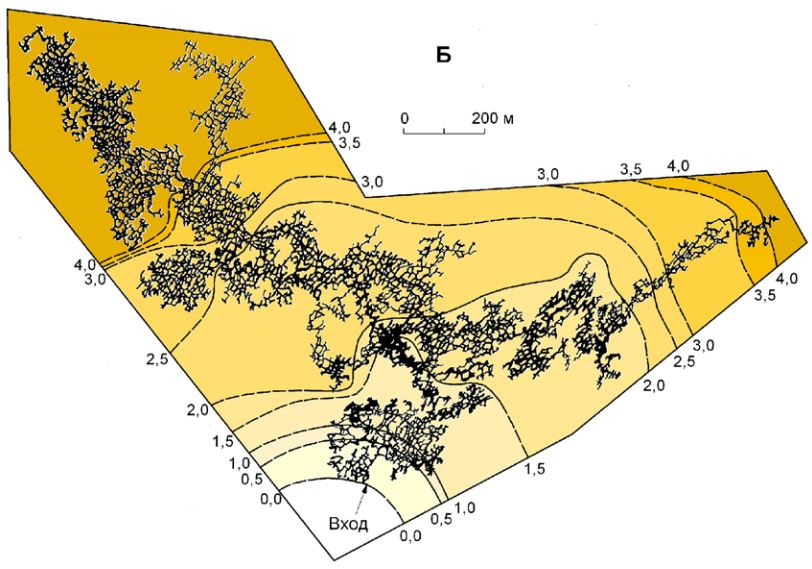
Topographic map of Zolushka cave (Authors: ABIS Club from Chișinău and Troglodyt Club from Chernivtsi, period 2006–2022)
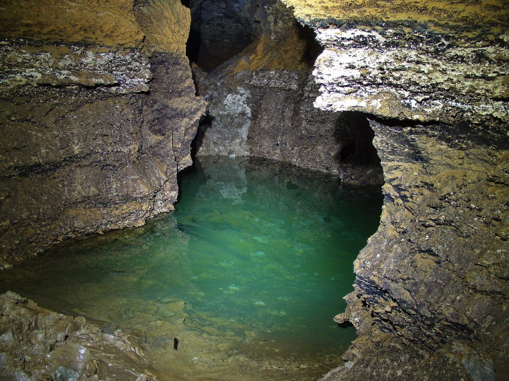
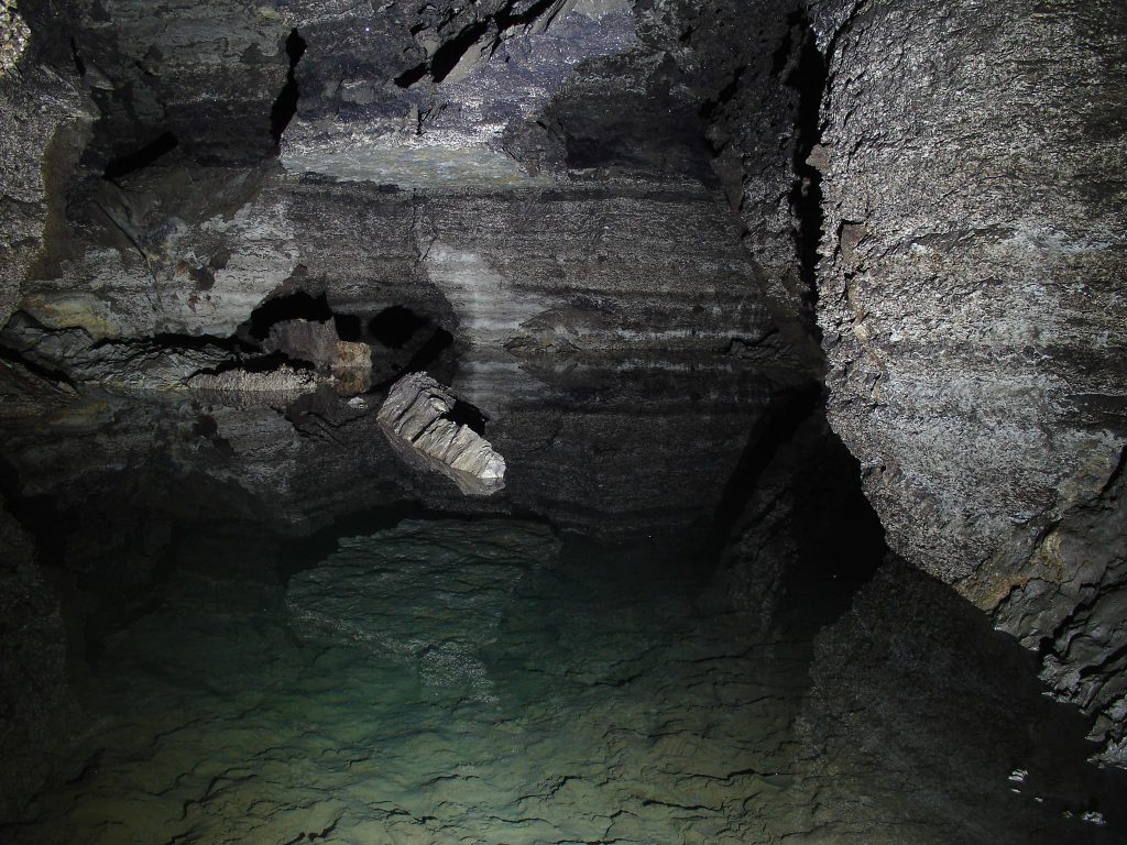
Water Bodies. In total, there are 36 lakes and 76 flooded areas in the cave. Their levels are dynamic, and some underground water basins have appeared or disappeared completely since the cave’s discovery. These basins appeared more frequently in the late 1970s and early 1980s, when the wet clay floors of the passages still possessed water-repellent properties. As the cave dried and the clay deposits cracked, losing their ability to retain water, this phenomenon ceased. Level fluctuations in the cave reservoirs are primarily associated with the water pumping regime from the gypsum quarry (averaging 8 tons/day), superimposed on minor natural groundwater fluctuations, and have small amplitudes of 0.1 m to 0.3 m over 10–15 years of observation. However, in certain years (1983–1984), a water level increase of 1.5 meters was observed in some parts of the cave. [1, p.180]
Underground lakes often have a grayish-blue tint due to the optical interaction with sediments and, to a lesser extent, the increased content of iron oxides.
Chemical Composition of Waters. Before the opening of the cave by a gypsum quarry, the stagnant regime of the karst waters predetermined a high mineralization of up to 4–5 g/l and hydrogen sulfide saturation of up to 120 mg/l. Under the conditions of activated water exchange, the water mineralization decreased to 2.5–2.9 mg/l. In the late 1980s and early 1990s, the average mineralization of the waters in the cave was 2.9 mg/l. The main reason for the high salinity of the karst waters is their interaction with soluble rocks and the stagnant regime of water exchange. The water pH varies from 7.8 to 9.0. This is evidenced by an increased amount of calcium, sulfates, and silicon dioxide. Among the microelements, Sr, Mn, Li, Zr, and Ba predominate. [1, p.184-189]
Gas Composition of the Air. This is characterized by a high content of CO2 (0.2–4.5%), N (79.6–83.1%), and a low content of CO2 (13.7–19.5%). The increase in CO2 concentration is associated with poor natural ventilation in the deep parts of the labyrinth. In the bottom of the deepest fissures and well-formed depressions, the CO2 concentration can reach 4–6%, which poses a certain danger to researchers. Exploration in the cave is hindered by the high concentration of carbon dioxide, the level of which increases with the distance from the cave entrance, reaching 1.00% after the first 500 m and exceeding 4.0% at the extreme points of the labyrinth. Periodic measurements show that the carbon dioxide concentration increased 1.5–2 times between 1980 and 2008. Current measurements show a further increase. For this reason, speleologists spend only a limited amount of time in the cave. With a CO2 content of 1–2%, speleologists experience the first symptoms of CO2 poisoning: skin redness, difficulty breathing, throbbing in the temples, and rapid heartbeat. In 1999, after the collapse of the cave entrance structure, a gradual accumulation of carbon dioxide began. An attempt by four visitors to enter the cave through the entrance shaft ended tragically for two of them—fatal CO2 poisoning. [4]
CO2 Concentration in the Cave Air during the Period of August 27–28, 2009, %
Source: V. Andreychuk, I. Teleshman, P. Kuprich, “Spatial dynamic characteristics of CO2 distribution in the air of Zolushka cave” Speleology and Karstology 7 (2011), p. 15-25.
Biota. Due to the fact that the cave is a recently drained collector of karst waters, there are no higher life forms, except for those introduced accidentally.
In the mid-1980s, a cycle of specialized microbiological studies was conducted at the biotechnology laboratory of the Institute of Physical Chemistry of the Academy of Sciences of the Ukrainian SSR (Lviv), aimed at establishing the typological spectrum of microorganisms specific to the cave. Physiological groups of thiobacteria, sulfate-reducing bacteria, hydrogen-producing, denitrifying, methanogenic, and iron-oxidizing bacteria were studied (Acidithiobacillus thiooxidans, Clostridium, Desulfovibrio desulfuricans, Methanobacterium formicicum, Pseudomonas, denitrifiers). The accumulation of hydrogen sulfide in the cave, the formation of sulfur compounds, the accumulation of carbon dioxide and nitrogen in the air, and the formation of iron-manganese deposits are considered consequences of the vital activity of these microorganisms. [1, p. 273]
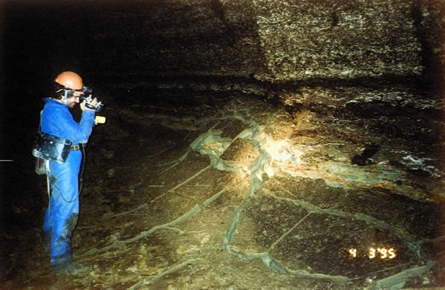
Research and exploration of new cavities. In the first month after the discovery of the system, Ukrainian speleologists mapped 10 km of cave passages. From 1978 to 1982, the length of the passages increased from 20.3 km to 61.9 km, and by 01.01.1984 – 76.0 km. [1, p. 11]
Since 1984, the “Abis” speleology club from Chișinău joined the exploration of the cave. In the following 15 years, thanks to the collaboration between Ukrainian and Moldovan speleologists, over 95% of the karst system was mapped, and the total length of the galleries reached 90 km.
After 2005, Moldovan and Ukrainian speleologists made great efforts to re-map the cave using more modern methods, which you can read about here. A more precise digital map of the cave was developed. The latest accumulated data show that the total length of the cave differs little from the data obtained during the first survey and is 92 km in plan and 87 km in relief, with a surface area of 206,432 m^2 and a volume of 546,710 m^3.
Over 50 speleologists were involved in creating the topographic map of the cave. Only two speleologists in the entire history of mapping the cave took on the role of work coordinator, as well as all office work regarding data processing: Vyacheslav Korzhik in the 20th century and Igor Teleshman in the 21st century.
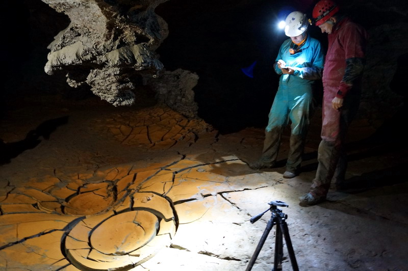
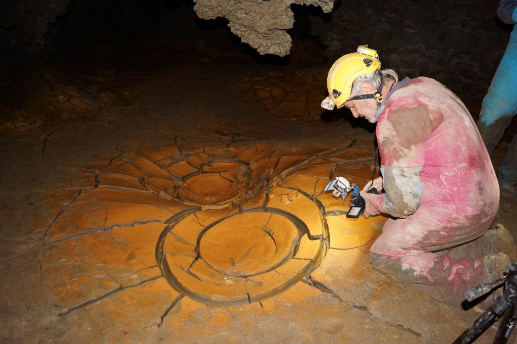
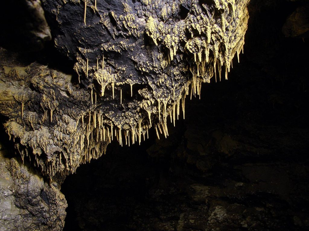
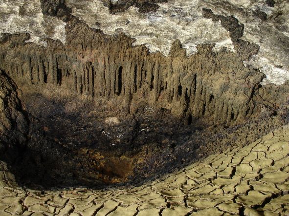
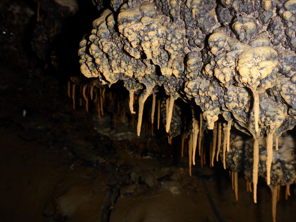
The greatest discoveries took place before the 1990s. One can only imagine the amazement of the discoverers who, passing through the narrow galleries at the cave entrance, entered for the first time the immense 9 m high halls, discovered over 60 underground lakes with clear water, found unique formations such as biogenic stalagmites and stalactites made of fine clay, gypsum needles – anthodites up to 15 cm long, clays of various colors, thin films of iron oxide and manganese oxide on the walls and ceilings of the galleries, gypsum monocrystals, and walls and ceilings shimmering with gypsum crystals or covered with birnessite. Every year, the cave grows in length by several dozen or hundreds of meters, and speleologists discover something new for themselves.
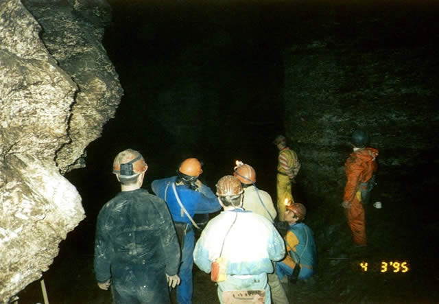
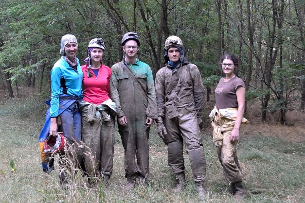
Despite the sharp decline in the club’s activity following the collapse of the USSR, after the second reopening of the cave starting in 2005, over 165 expeditions have been organized by Moldovan speleologists, all of which have been documented. Main directions: topography, monitoring, and video/photo capture. [5]
The gypsum deposits in the karst area make the future expansion of the cave possible. This, along with many unexplored processes within the cave, makes it attractive to amateur speleologists and scientists from around the world.
The most extensive description of the cave was published in the monograph “Zolushka Cave” by Vyacheslav Andreichuk in 2007. It contains data on the cave’s study process, the natural and karst conditions of the area, the geology, morphology, and morphological structure of the labyrinth; the most detailed topographic maps of each cave region are presented; there is a detailed description of the role and properties of groundwater; the microclimate was analyzed and data on biological studies of microorganisms were collected; data on the origin and age are presented, and the scientific and practical significance of the cave is formulated.
Between May 14 and May 17, 2009, the Ukrainian Institute of Speleology and Karstology of the Ministry of Education and Science of Ukraine and the National Academy of Sciences of Ukraine, in partnership with other organizations, organized the international conference “Hypogenic Speleogenesis and Hydrogeology of Artesian Karst Basins.” A total of 57 scientists from 23 countries (Austria, Australia, Brazil, Great Britain, Germany, Greece, Israel, Spain, Iraq, Italy, Canada, Mexico, Norway, Poland, Russia, Romania, Slovenia, Slovakia, USA, Turkey, France, Ukraine, Switzerland) were among the participants. Thirty-nine reports were presented, and an extensive scientific discussion was held on the problems of defining the concept and establishing criteria for identifying hypogenic speleogenesis. [6]
The cave was visited by Penelope Boston, a microbiologist involved in the search for possible life forms on Mars at NASA. A scientist who “knows every microbe by sight,” she was interested in the clay stalactites, which, in all probability, are of biological origin. The cave immediately gained a unique global status as a place where “living” stalactites are found! [5]
Unfortunately, for some reason, scientists from the Academy of Sciences of the Republic of Moldova were absent from this conference.
In parallel with scientists from Ukraine, starting in July 1977, researchers from the Academy of Sciences of the MSSR, as well as students from the Tiraspol State Pedagogical University under the guidance of V.N. Verina, worked in the cave. The main research areas were: mapping, description of cave morphology, collection of samples for laboratory analysis, and the study of living organisms. Subsequently, the first map was published, and the total length of the captured passages was approximately 10 km. [7, pp. 76-79]
Several topographic schemes of the cave created by Moldovan scientists have been published in various sources. Noteworthy is the 2008 publication by Constantin Moraru, “Karst in the Gypsum of Northwestern Moldova.” The book describes the karst processes in the gypsum of northeastern Republic of Moldova, designated as the “Criva-Drepcăuți Karst Zone,” which includes the cave. It presents the results of complex hydrogeological, hydrological, geochemical, speleological, and geological studies conducted using international karst study methods, including modern computer programs. In this publication, the total length of the studied galleries was declared to be “greater than 100 km”; simultaneously, for the first time, Moldovan scientists published the first map of the cave in 2006, produced by professional Romanian speleologists from the Emil Racoviță Institute of Speleology in Bucharest, illustrating a 2.6 km labyrinth. [8] There is no data on the extended map.
It is curious that there is no data regarding cooperation between Moldovan speleologists and Moldovan scientists from the Academy of Sciences either before or after Moldova gained independent country status.
Each group conducted research, published maps, topographic diagrams, and scientific publications (60 geo-karstic and 40 speleological and medical). [1, p.16] Some can be read here. Parallel studies led to the emergence of different toponyms for the same given areas of the cave:
Komsomolists Lake = Long Lake
Dog’s Hall = unknown
Green Lake = Green Labyrinth Lake
Hippopotamus Lake = Crocodile Lake
Gura-de-Apă Lake = Fragments Lake
Moldova Lake = Nautilus Lake
Cemetery of Dinosaurs Hall = Dinosaur Hall
Penguins Hall = Penguin Hall
The Well = Larisa’s Well
Uniqueness. From V. Andreichuk’s monograph “Zolushka Cave”: “From the very first months of its discovery, the cave attracted the attention of speleologists, and later—geographers, geologists, and physicians. It became a worthy addition to the ‘constellation’ of the largest studied gypsum caves in the neighboring Podolia region, yet it proved to be different from them. Unlike the Podolian labyrinths, it is more voluminous. To a greater extent than the labyrinths of Podolia, Zolushka is filled with clay deposits. The cave galleries are primarily situated in the upper part of the gypsum layer, resulting in many landslide areas within it.
The main characteristic of the cave is that it was opened artificially (by a quarry) at a stage when the cave was still almost completely flooded. The Podolian labyrinths passed through this stage tens of thousands of years earlier. The recent drainage and the younger age of the cave predetermined the originality of its internal appearance (increased moisture content of sediments, absence of secondary gypsum formations so characteristic of Podolian caves, etc.) and the activity of various processes (collapse of vaults, drying of sediments, water flow between zones, etc.), accompanying a abrupt transition of the cavities from a watered to a dry state.
It was not only the external differences and contrasts with other caves in the Western Ukraine region that drew everyone’s attention to the cave. From the very beginning, it became clear that a new, scientifically interesting object had been discovered, providing a unique opportunity to conduct versatile research. Speleologists encountered many of the phenomena and processes observed in the cave for the first time.” [1]
Protection and Access. In 1969, the Department of Geography of the Academy of Sciences of the Moldavian SSR proposed to take under state protection as natural monuments two entrances first discovered by V.N., as well as an ascending source of mineral water of the hydrocarbonate-sulfate-sodium-calcium-magnesium type with a flow rate of 280 l/s. [7]
In 1979, thanks to the efforts of V.P. Korzhik, the cave was declared a geological natural monument of local and republican importance on the territory of Ukraine.
The legal status of an object protected by law extended only to the Ukrainian half of the cave. At the same time, the entrance to the labyrinth (the quarry) was located on the Moldovan side, where the destruction of the entrance parts of the cave occurred due to quarrying. The vigorous activity of speleologists from Chernivtsi, with the support of the Union (still under the USSR) and international public bodies and organizations, made it possible to influence the Ministry of Construction Materials of Moldova, which managed the Krivsky quarry, leading to the relocation of the mining front east of the labyrinth in 1985. At the same time, the cave entrance was saved from being filled with landfill waste. [1]
Immediately after the collapse of the USSR, the cave was taken under the state protection of the Republic of Moldova, and it is currently protected by “Law No. 1538-13” of June 25, 1998, regarding the State Fund of Specially Protected Natural Territories. It is classified as a natural monument of a geological or paleontological type and is administered by a gypsum quarry in the village of Criva. [13]
In 1999, under the action of lateral pressure and its own weight, the base of the concrete shaft was deformed, and the entire structure sank. The entrance was filled with mud. Repair work carried out in 2006 reopened access to the cave. Following rehabilitation work carried out over the last decade, the entrance shaft is now located among plantations of young trees. The entrance to the cave was locked and remains so to this day. [1]